


snowhow freeride
snowhow freeride介绍
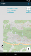
The SNOWHOW-Freeride App offers offline use of maps from the Alps. With an adjustable layer you can check the incline (steepness) of the slopes.
The slope incline is a key parameter for European decision making strategies in wintery and avalanche prone terrain.
The SNOWHOW-Freeride App is no substitute for any other tools of orientation and decision making and necessary safety gear. Shown tracks and map information are not recommendations for any terrain use.
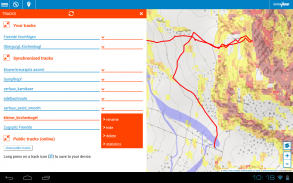
Track recording:
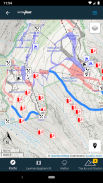
The GPS-function of your phone allows you to find your current position on the map.
Combined with the color coding of the slope incline, you can evaluate the terrain around you.
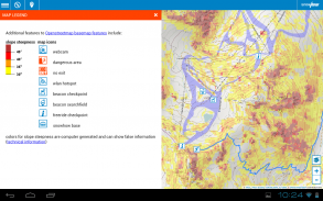
Color coding for incline:
The color coding shows the steepness of the terrain in four sectors.
These sectors are used in decision making strategies in Europe. The knowledge and correct use of decision making strategies (see http://goo.gl/y5Rmx ) is essential to be able to use the SNOWHOW-Freeride App properly. If you are not familiar with any kind of decision making strategies or any other knowledge about decision making in avanlanche prone terrain, do not use the SNOWHOW-Freeride App.
Resolution and color coding:
Each color coded tile shows an area of 10 x 10 metres or real terrain. Keep in mind, that within 10 metres the steepness of a slope can change dramatically.
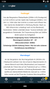
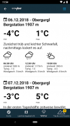
Weather data and Avalanche Bulletin:
If you go online with your smartphone, the SNOWHOW-Freeride App will automatically load the newest avalanche bulletin.
SNOWHOW-Freeride应用程序可离线使用阿尔卑斯山的地图。通过可调整的层,您可以检查坡度(陡度)。
坡度是冬季和雪崩高发地区的欧洲决策策略的关键参数。
SNOWHOW-Freeride应用程序不能替代任何其他定向和决策工具以及必要的安全钳。不建议在任何地形上使用显示的轨迹和地图信息。
录音:
手机的GPS功能可让您在地图上找到当前位置。
结合坡度的颜色编码,您可以评估周围的地形。
倾斜的颜色编码:
颜色编码显示了四个扇区的地形陡度。
这些部门用于欧洲的决策策略。知识和正确使用决策策略(请参阅http://goo.gl/y5Rmx)对于能够正确使用SNOWHOW-Freeride App至关重要。如果您不熟悉任何类型的决策策略或其他在山崩多发地区的决策知识,请不要使用SNOWHOW-Freeride App。
分辨率和颜色编码:
每个用颜色编码的图块都显示10 x 10米的区域或真实地形。请记住,在10米以内的坡度会发生巨大变化。
天气数据和雪崩公告:
如果您使用智能手机上网,那么SNOWHOW-Freeride应用程序将自动加载最新的雪崩公告。
snowhow freeride - 版本2.0.26
(02-11-2021)snowhow freeride - APK信息
APK版本: 2.0.26程序包: info.snowhowsnowhow freeride的最新版本
其他版本


同类应用


